Categories
Uncategorized

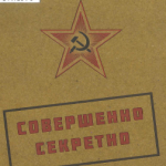
The red atlas : how the Soviet Union secretly mapped the world / John Davies, Alexander J. Kent ; foreword by James Risen. (OCLC #978389095)

This volume has “atlas” in its title, and has quite a few maps in it, but is it really an atlas? Catalogers disagree; OCLC has multiple records for this title, mostly as a book, but one as an atlas.

Our maps cataloger took a closer look, and said that while it had a large section of maps, they were used as illustrations for the text, not the main content of the work themselves. I did feel the maps were numerous enough to merit inclusion in the content type though:

336  ǂa text ǂb txt ǂ2 rdacontent
336  ǂa cartographic image ǂb cri ǂ2 rdacontent
Categories
Uncategorized

The lands of ice and fire : maps from King’s Landing to across the Narrow Sea / George R. R. Martin ; cartographer, Jonathan Roberts. (OCLC #869897510)

We received this item for cataloging: a case of 12 folded maps based on George R. R. Martin’s “A Song of Ice and Fire” books. We found two good and reasonably popular records that matched:

  • OCLC #800039897 (54 holdings)
    • uses the “Visual materials” workform
    • main entry George R. R. Martin; Johnathan Roberts as illustrator
    • physical description: 12 posters
    • content type: still image
    • classed in PS with Martin’s other works
  • OCLC #869897510 (25 holdings)
    • uses the “Maps” workform
    • main entry Johnathan Roberts as cartographer; George R. R. Martin’s work included as a subject and an added entry
    • physical description: 12 maps
    • content type: cartographic image
    • classed in G with maps

If we were adding this to our main library collection, I could see using the poster record, but we are cataloging it for the maps library, so the second is more appropriate; the individual maps will be stored flat in our map case. We checked the catalogs of other libraries who chose the map record, and found that some of them classed it under G3122 (Atlases of imaginary, literary, and mythological regions, etc), and others under G9930 (Maps of imaginary places); we’re considering this a set of maps (not an atlas) so will class under G9930.

Categories
Uncategorized

New Orleans street map : features full street index, schools, shopping malls ; included Gretna, Harahan, Kenner … orientation map. (OCLC #881472331)

Due to recent staffing changes and re-organization, our map cataloger is now part of my cataloging and metadata group. I am beyond delighted! She’s great, and map cataloging problems are wily ones.

This map appears to have two copyright statements from different corporate bodies, and different dates. The cover lists Rand McNally ©2013, and the statement below the legend has the publisher GM Johnson & Associates ©2014.

RDA 2.11.1.3 on Copyright Dates says that when multiple copyright dates apply to a single aspect (and I don’t have any evidence that they are for specific aspects) to record only the latest copyright date. Stonybrook’s guide even mentions this case specifically for maps. We also included both firms as publishers in a single 264 field:

    264 _1 ǂa [Burnaby, B.C.] : ǂb GM Johnson & Associates ;
        ǂa Chicago, IL : ǂb Rand McNally, ǂc [2014]

Library of Congress’s training materials say it would be incorrect to use separate 264s for this.

Categories
Uncategorized

Areawide land capabilities and natural resources utilization study, FIVCO ADD : Greenup, Boyd, Carter, Elliott, Lawrence / prepared by Mayes, Sudderth & Etheredge, Inc. (OCLC #871201008)

This large folded map shares most metadata (title, creator, date down to the month) with a book we already have in storage, though its record doesn’t mention an accompanying map of FIVCO (“the five county area”).

If I’d had both of these in hand initially, I probably would have cataloged them together, with a physical description like:

300 __ ‡a 62 pages ; ‡c 28 cm + ‡e 1 folded map.

(note the lack of period after the cm, that would have been there under AACR2!)

Substantive accompanying materal does justify a new record in OCLC, so I didn’t want to just tack it on to our local book record. I passed it on to our map cataloger, who added it to our map collection with its own original record.